
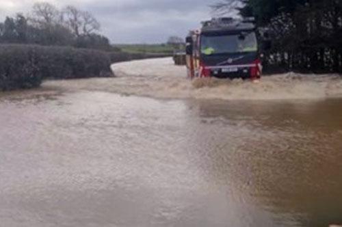
Drivers and residents are now being asked for their views on proposals to deal with repeated flooding on the A4118 near Scurlage and Llandewi Corner – a key route used by locals and visitors heading to the Gower coast.
The stretch of road can become completely impassable during heavy rain, leaving residents cut off and causing major disruption for motorists travelling through the area.
Council engineers are now looking at a range of possible fixes.
These include installing larger drainage pipes to carry more water, improving links between drainage systems and nearby streams, and even raising sections of the road so vehicles can still get through during downpours.
Other options being explored include nature-based measures designed to slow the flow of water before it reaches the road, as well as improving maintenance of the drainage network.

(Image: Swansea Council)
The proposals are still at an early stage, but the council says public feedback will help decide which solutions move forward.
Andrew Stevens, the council’s cabinet member for environment and infrastructure, said the flooding problems have been affecting the area for years.
“The route between Scurlage and Llandewi suffers from flooding when we have heavy rainfall and can make the road completely impassable,” he said.
“That can prevent residents from leaving or entering the area.
“We now want to look at the options developed and see which can help prevent this happening in the long term.”
The work forms part of a wider programme looking at flooding hotspots across Swansea’s road network.
Both the Scurlage location and another trouble spot at Killay Square have received funding through the Welsh Government’s Resilient Roads Fund, which has provided around £265,000 to investigate solutions.
While the Killay scheme has already moved further along in the design process, the Scurlage proposals are now entering the consultation stage.
Council chiefs say feedback from residents and road users will help shape the final plans before they bid for further funding to take the project forward.
People who want to have their say can complete the online consultation on the council’s website.