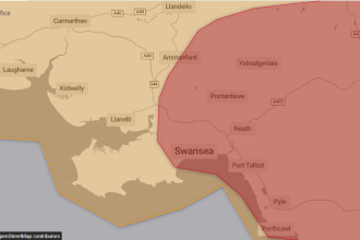

Yellow warnings in place for South Wales
The Met Office has issued Yellow weather warnings for rain across South Wales, including Carmarthenshire, Pembrokeshire, Swansea and Neath Port Talbot, as Storm Ingrid brings another spell of wet and windy weather to the region.
Forecasters say the storm — named by the Portuguese national weather service — will sweep in from the southwest early on Friday, with conditions expected to worsen through the day and into Saturday morning.

“Potential for disruption” across the region
Met Office Chief Forecaster Neil Armstrong said the system could cause problems even though rainfall totals in Wales won’t reach the extreme levels expected in parts of Scotland.
“While rainfall totals in Northern Ireland, south Wales and parts of the southwest of England won’t reach those that we’ll see in parts of Scotland, there’s still a potential for some disruption, particularly for travel.”
The Met Office says the warnings highlight the risk of fast‑flowing or deep floodwater, difficult driving conditions and the possibility of some communities being temporarily cut off.
⚠️ Yellow weather warning issued ⚠️
Rain & wind across southern parts of Wales and southwest England
Friday 02:00 – Saturday 09:00
Latest info 👉 https://t.co/QwDLMfRBfs
Stay #WeatherAware⚠️ pic.twitter.com/Rg8eJViQVy
— Met Office (@metoffice) January 22, 2026Heavy rain falling on already saturated ground
Storm Ingrid is expected to bring more than 20mm of rain for some areas, falling on ground already soaked by weeks of unsettled weather. Forecasters warn that even modest rainfall could lead to surface flooding, swollen rivers and blocked routes.
Along the coast, large waves and strong gusts are likely, with winds of 45–50mph inland and peaks of up to 60mph possible in exposed areas.
Friday looks worst for South West Wales
The Met Office says the worst of the weather for Wales will arrive on Friday, with rain pushing in from the southwest and lingering into Saturday morning before easing.
Scotland will continue to see the heaviest rainfall, with some high‑ground areas expected to exceed 100mm, but South West Wales remains firmly in the zone for disruption.
More unsettled weather to follow
Low pressure will continue to dominate through the weekend, bringing further spells of rain and wind. Looking ahead to next week, the Met Office says there is still uncertainty, but wintry conditions are possible in parts of the UK, especially further north and east.