Getting the kids to school on foot. Cycling to the station instead of driving. Reaching the local park without walking along a busy road.
These are the kinds of everyday journeys behind a set of new walking, wheeling and cycling routes proposed across Neath Port Talbot, which the council says would make active travel easier and safer.
The council has drawn up a long list of routes it wants to add or improve, each one intended, it says, to fix a spot where getting around without a car is currently hard, unsafe or impossible.
There is a catch worth stating up front: these are “future routes” — lines on a map marking where the council wants to act, not funded, designed schemes with a start date. But routes have to be on the map to qualify for Welsh Government money, which is why the council wants views now.
Here’s a flavour of what’s proposed, area by area.
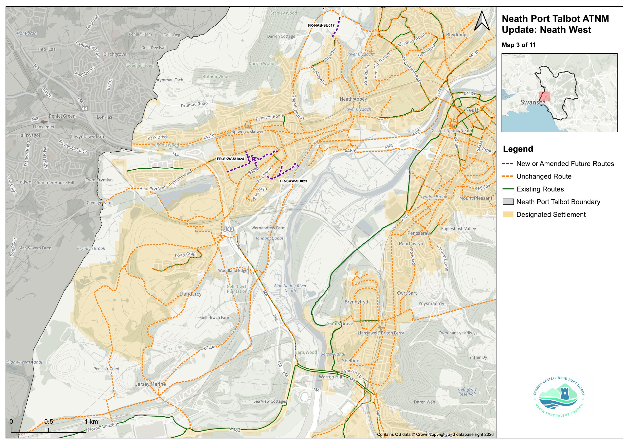
Neath, Skewen and the surrounding villages
In Skewen, the railway currently cuts the village off from Neath Abbey. The council is proposing a route along the lane between Pale Road and the railway bridge, with a link along Cardonnel Road, which it says would reconnect the two — plus a separate path through Skewen Park to create a traffic-free way across the village.
At Cadoxton, a new path along Bryn Catwg would, according to the plans, give families a step-free route to Cadoxton Community Park.
Aberdulais and Cilfrew are split by the railway and the River Dulais. The council says a proposed route over the bridge, joining New Road to Cefn-yr-Allt, would connect the two communities.
For commuters, the council has placed some of its highest-priority schemes around Neath train station, with another new link aimed at getting people safely to Briton Ferry station.

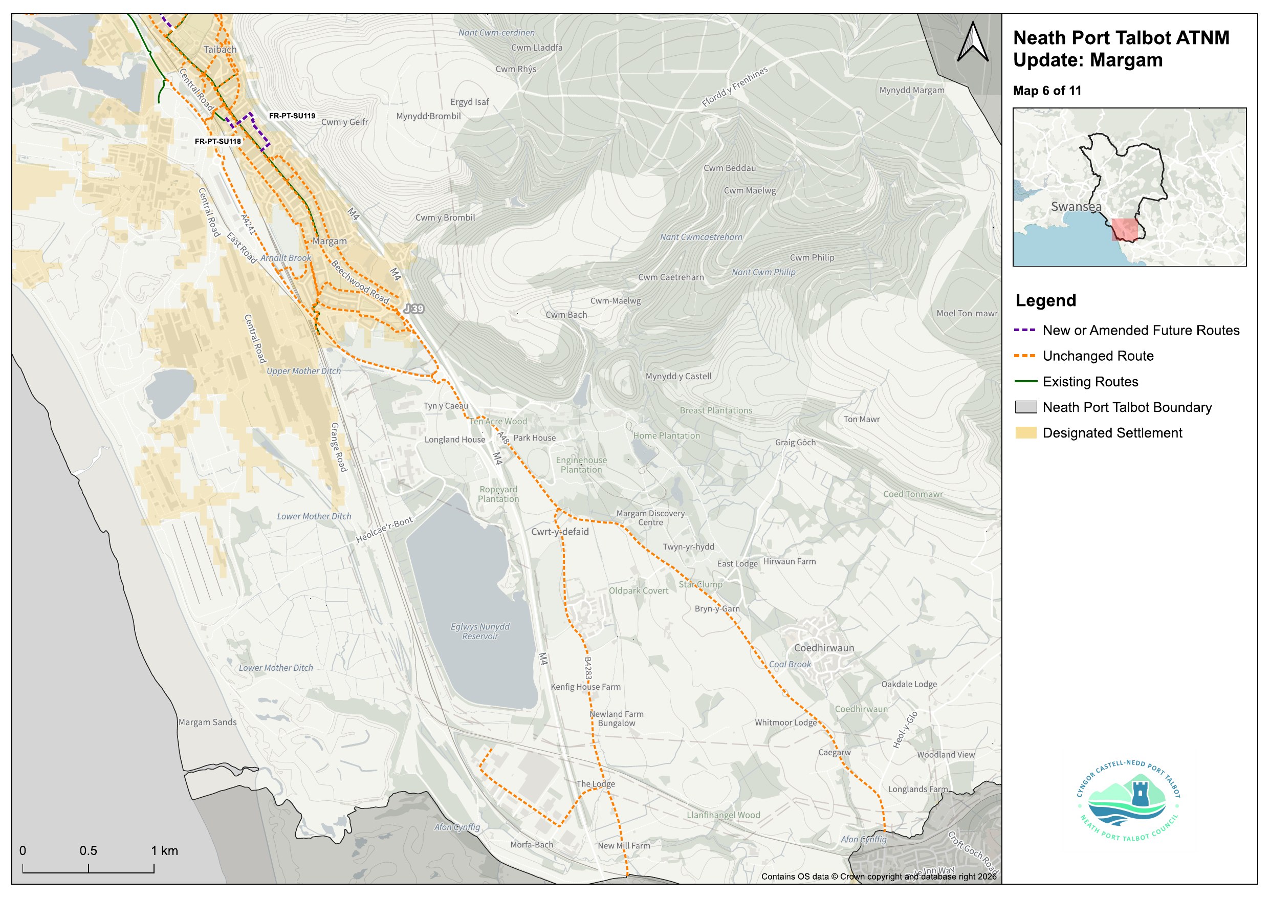
Port Talbot, Aberavon and Taibach
In Taibach, the council says a route along Lady Charlotte Lane would make it easier to reach the community centre, the education centre and Mount Surgery.
A second Taibach route, along the path between Wood Street and Elba Avenue, is intended to improve the traffic-free options through Margam’s residential streets.
In east Port Talbot, the plans propose a route along Pen-y-Cae Road to improve access around the Tan-y-Groes Street roundabout.
Much of Port Talbot’s town centre, seafront and Sandfields network already ranks among the highest-priority routes in the borough, alongside a proposed walking and cycling link to Neath Port Talbot Hospital.

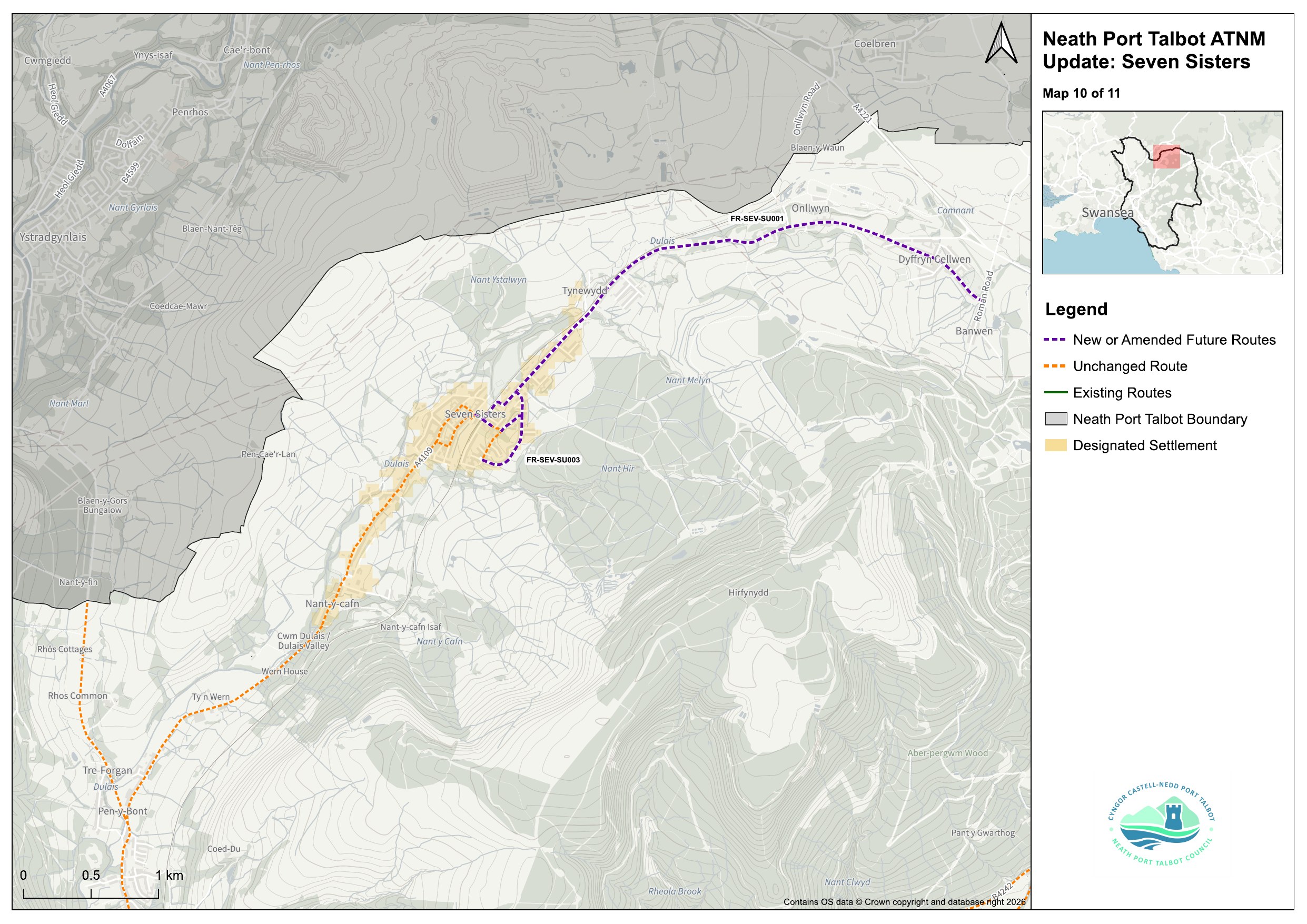
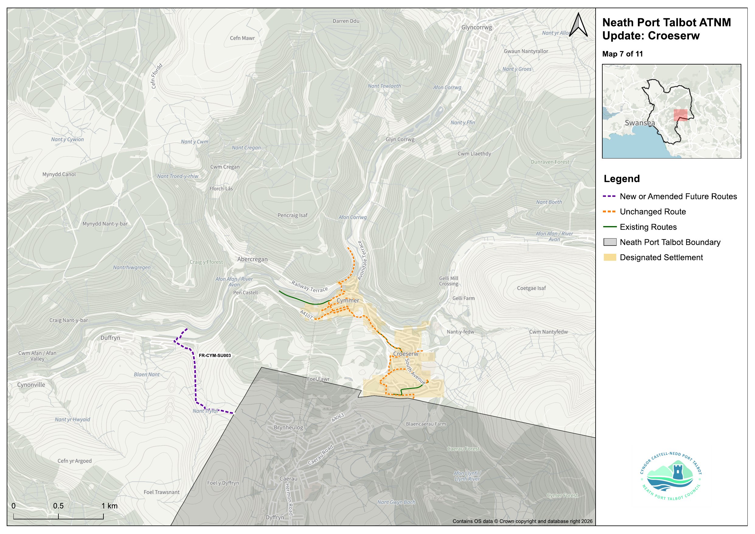
Cwmavon, Glynneath and the Neath valleys
At Cwmavon, the council is proposing an off-road path along the western bank of the River Afan, which it says would give people on the Gwaun Afan estate a direct, traffic-free route in and out, tying into National Cycle Network Route 887.
In Glynneath, the plans include a route from the B4242 to the library, intended to put key community buildings within safe reach on foot or by bike.
At Resolven, the council is proposing a quieter alternative to the B4434 along Heol Herbert.
In Seven Sisters, officers say a route along Heol Heddwch and Tan-y-Rhiw would give children a safer way to reach Blaendulais Primary School and connect homes to the village’s sports and play facilities.
Also at Resolven, the council is proposing to extend an existing route along the B4434 to Melincourt, to serve possible new housing sites.
In Croeserw, the plans propose a walking route linking Viaduct Road to the village via Eastern Avenue, South Avenue and Bryn Siriol.


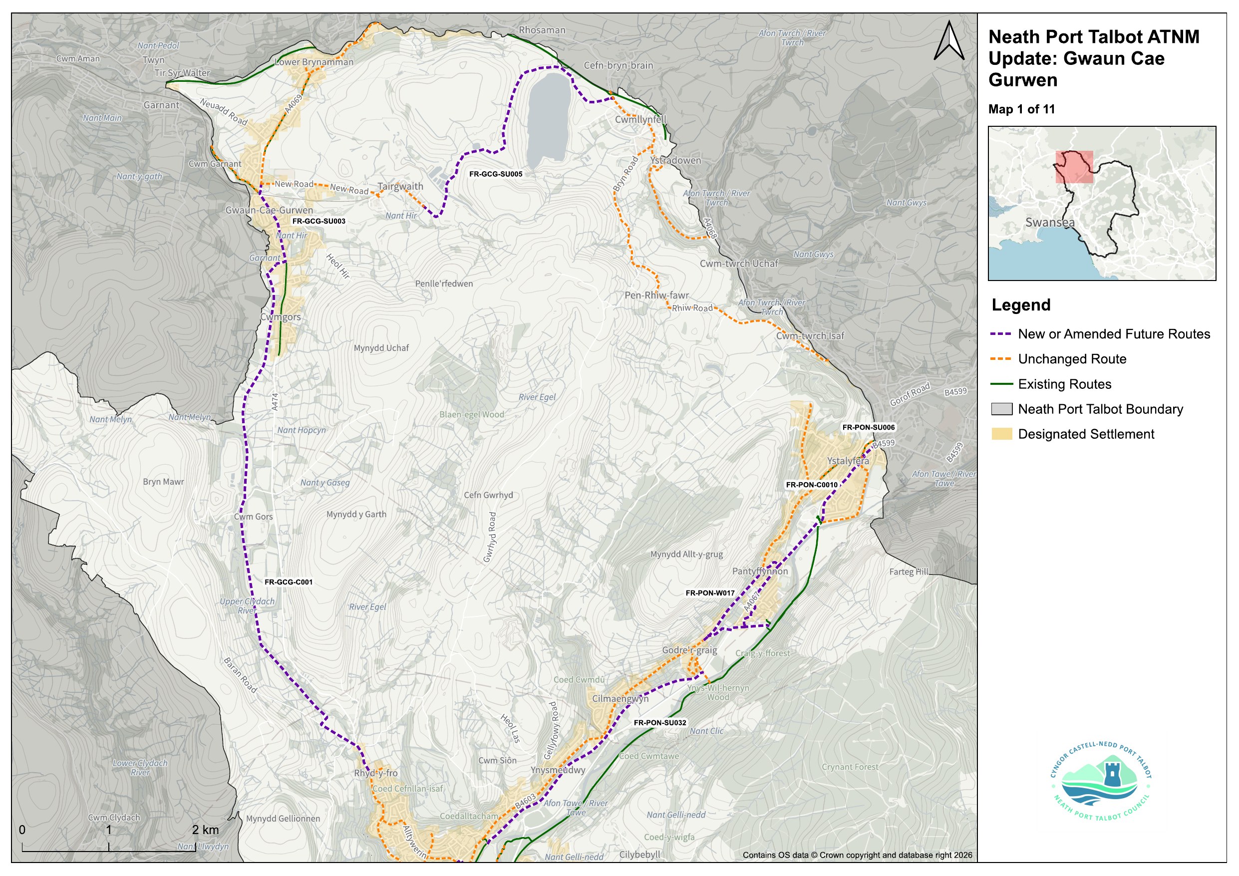
Pontardawe and the Swansea Valley
Along the Swansea Canal near Pontardawe, the council is proposing a towpath route it says would create a continuous, car-free path through the Swansea Valley.
Elsewhere in Pontardawe, the plans note that the A474 currently allows no pedestrian access, and propose a new link up to Glan-Rhyd Road to address it.
Higher up, a future route from Tairgwaith to Cwmllynfell, via the reservoir, is intended to open access to a new visitor destination in Gwaun-Cae-Gurwen.

How the routes are chosen — and how to have your say
Each route has been scored and ranked by Transport for Wales, which weighed how many people would use it and how well it connects schools, workplaces and local centres. That ranking helps decide which come forward first.
But the council is clear that ranking doesn’t guarantee delivery: every scheme still depends on funding, design and further consultation.
Cllr Wyndham Griffiths, the council’s cabinet member for strategic planning, transport and connectivity, said the aim was to help people make everyday journeys — to school, work or the shops — in a healthy, safe and sustainable way.
He said the consultation gave people and businesses a chance to say where changes were most needed, which would then shape the council’s funding bids.
The council says it especially wants to hear where walking, wheeling or cycling currently feels unsafe or difficult, and where links between communities are missing.
The 12-week consultation runs until 21 September. People can complete an online survey on DataMapWales, or view paper copies at Neath and Port Talbot libraries. Drop-in events will run over the summer, with dates listed at npt.gov.uk/activetravel.
This consultation follows earlier council proposals for active travel schemes across the borough, including a major revamp for Sandfields and Aberavon, a masterplan for Neath town centre and a proposed Neath to Cimla route.