

A sweeping redraw of Swansea’s walking and cycling network goes before councillors on Thursday — and it sets out where the city could walk, wheel and cycle for years to come.
Swansea Council’s cabinet will be asked to approve a refreshed draft Active Travel Network Map, clearing the way for a 12-week public consultation this summer.
Every council in Wales has a legal duty under the Active Travel (Wales) Act 2013 to map existing and future routes for walking, wheeling and cycling, and to refresh that map regularly. Swansea’s current version was approved in 2022.
The refreshed draft has to reach the Welsh Government by 1 December 2026 — and a six-week engagement exercise over the winter has already shaped it, drawing 548 responses and feeding 39 changes into the map before it has even reached cabinet.
Cllr Andrew Stevens, the council’s cabinet member for environment and infrastructure, is recommending the draft for consultation.
The council is at pains to stress one point: putting a route on the map does not mean it is funded, or that it will be built. The map is a long-term planning tool, and each route would need its own funding and approval further down the line.
The numbers behind it are substantial. Council teams carried out 32 cycling and 33 walking route audits over the winter, logging nearly 500 barriers, more than 1,000 crossings and over 500 public seats along existing routes.
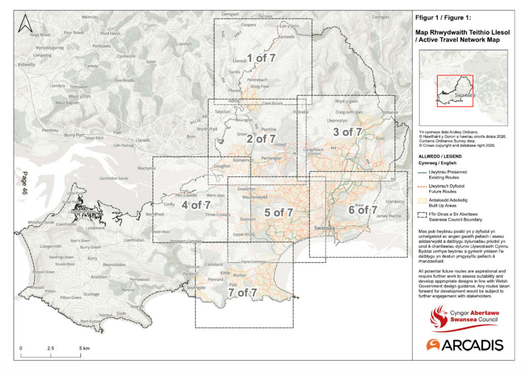
So what’s changing, and where? Here’s the breakdown across the seven areas the map is split into.
Pontarddulais and the north
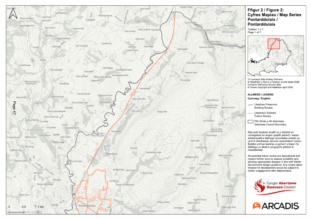
At the northern edge of the city, the main proposed route through Pontarddulais has been reshaped. Part of it has already been built and now shows as an existing route, while a section that ran through the grounds of Pontarddulais Primary School has been removed, as it would not have been open for public use.
The route has been extended along Heol y Waun to connect with Glynhir Road, and another section at Gorsaf y Glowr was taken out after a member of the public pointed out that a parallel path had already been created.
The area also takes in the map’s longest single proposed route, a future link running north from Pontarddulais up through Garnswllt towards the county boundary.
Gorseinon, Loughor, Gowerton and Penclawdd

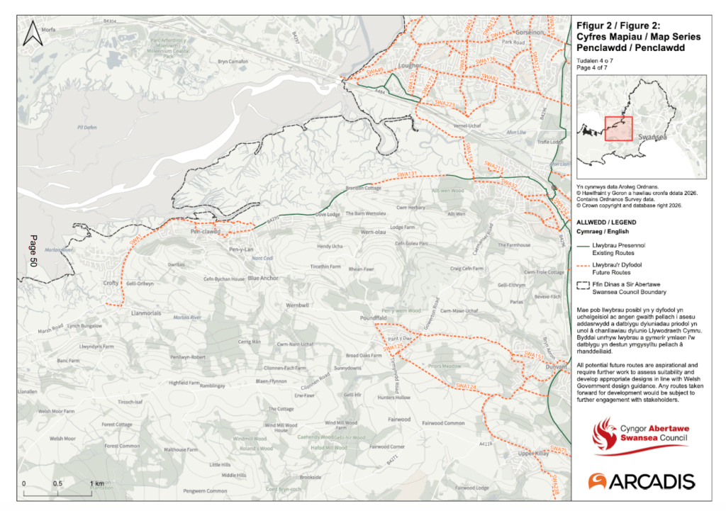
The north-west of the city is home to one of Swansea’s longest-running cycling campaigns — the so-called “missing link” between Gowerton and Penclawdd.
A shared-use path between the two has held planning permission since 2006, yet a stretch along the 40mph B4295 still funnels cyclists onto a narrow pavement or out into traffic. A petition by the North Gower Access Path group has gathered more than 1,500 signatures.
The draft map redraws that route, realigning it onto the B4295 and the off-road path between Gowerton Road and Beach Road, with new spurs to Penclawdd Primary School and Benson Road — an alignment the council calls more direct and coherent than the previous residential one.
Gowerton features again separately, this time looking east. When the council paused its controversial Walter Road and Sketty Road scheme in 2025 and diverted the £1.4m budget, some of that money went towards developing a new walking and cycling route between Loughor and Gowerton.
That route, along Culfor Road, has now been realigned on the draft map to match how the scheme is actually being designed — a sign it is among the more advanced proposals on the map.
The refreshed map carries fresh links in this corner too, including a route tying east Loughor and Gorseinon into the National Cycle Network and a traffic-free alignment between Gowerton and Fforestfach.
Residents’ suggestions also added new links to Gorseinon Primary and Llangyfelach Primary schools, a path connecting Melin Mynach park to Gorseinon High Street, and a Waunarlwydd-to-NCN4 route via an existing bridleway that avoids Gorwydd Road.
Clydach and the Tawe valley
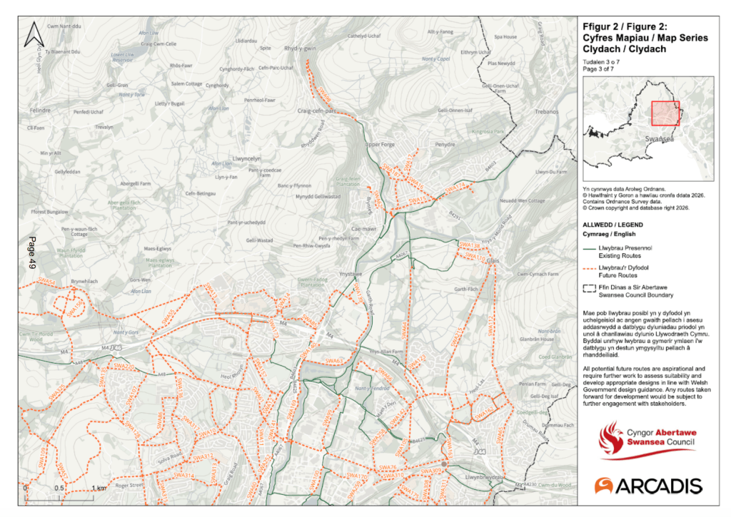
To the north-east, a new traffic-free route is proposed along an old railway track connecting Glais to Birchgrove — put forward by a member of the public as an alternative to the B4291.
The map also aims to reduce the severance caused by the M4 with a new link near Penllergare Valley Woods, where two further routes have been proposed by the landowner.
West Swansea — Killay, Dunvant and Sketty

This area carries the ghost of the most contentious scheme of recent years: the planned cycle route along Walter Road and Sketty Road, paused in 2025 with its funding redirected across the city.
On the new map, that corridor returns in pieces rather than as a single bold line. A new link from Phillips Parade to Duke Street would connect Guildhall Road South to Walter Road while avoiding the steep gradients of Brynymor Road, and a route through Sketty has been realigned along Eversley Road after a resident’s suggestion, with the original strategic alignment kept too.
A brand-new route across Fairwood Common is also proposed, providing a strategic link between Killay and Mayals via an existing bridleway.
Closer to the parks, residents suggested a path improving the connection between Uplands and Singleton Park via Beechwood Road, a new east-west route through Singleton Park itself, and a link to Dunvant Primary School.
The city centre and riverside

Down at the river, the £8m walking and cycling path along the River Tawe — the one engineers say will need barges to build — has driven changes here. The Tawe Riverside route has been extended to the A4067 to match scheme proposals, and the river bridge crossing realigned to better connect routes on both banks.
A new city-centre link along Victoria Road is proposed, joining Princess Way to Wind Street, while New Cut Road would be extended to connect with the Strand.
Across the river, new routes are pencilled in for Bonymaen: a Cefn Hengoed link connecting schools, playing fields and the GP surgery, and a footbridge route over the A4217 linking Landore to a key employment area.
Gower and Mumbles

In the south sits another long-campaigned-for connection — a safe route across Clyne Common linking Mayals with Murton and Bishopston, where at present there is no safe way to walk or cycle between the communities.
On the map it is built from two pieces: a continuation of the completed Mayals Road scheme running west across the common, and a branch dropping south to Bishopston. The wider scheme cleared a significant hurdle earlier this year when the Welsh Government approved it under the Commons Act, though the council still has to secure construction funding before any work can begin.
A web of connecting routes branches off it, suggested or refined by residents — linking Mayals to upper West Cross, West Cross to Newton and the local primary schools, and on towards the seafront, Mumbles and the National Cycle Network. A separate route through Mumbles, at Underhill Park, is already undergoing scheme development.
Not every Gower route survived. A planned path through Bishopston Valley has been dropped over gradient and deliverability problems, with a route via Pennard kept as the alternative.
The route residents killed off

The clearest proof that public feedback carries weight sits in Clyne Valley. The plan to upgrade the historic Old Carriage Drive bridleway — which sparked a public outcry and a council climbdown — has now been formally removed from the map, officers citing the local decision not to support the upgrade.
A separate section of a Langland route, at Rotherslade, has also been taken out, with officers noting it was more likely to be used for leisure than for everyday journeys and so unlikely to meet active travel funding rules.
What happens next
There is a real incentive for residents to get involved. The map is the gateway to Welsh Government cash: the council says routes that do not appear on it cannot receive active travel funding from the Welsh Government at all.
Being on the map is no guarantee a route will be built or funded — but being left off it rules that funding out entirely.
If cabinet approves the draft on Thursday, the 12-week statutory consultation will follow over the summer, with the map hosted on the DataMapWales website, paper copies in libraries, and drop-in events.
Residents will get a fresh chance to back routes, object to them, or suggest new ones before the final map is submitted to the Welsh Government in December.